FACTS ABOUT VOLCANOES
Did You Know?

- Over 50 volcanic eruptions rock our planet every year.
- 800 million people currently live within 60 miles of an active volcano.
- 280,000 people have been killed by volcanoes worldwide since 1500.
- 1300 degrees Farenheit is the maximum temperature of pyroclastic flows, very fast avalanches of rock, ash, and gas
- The word volcano originally comes from the name of the Roman god of fire, Vulcan.
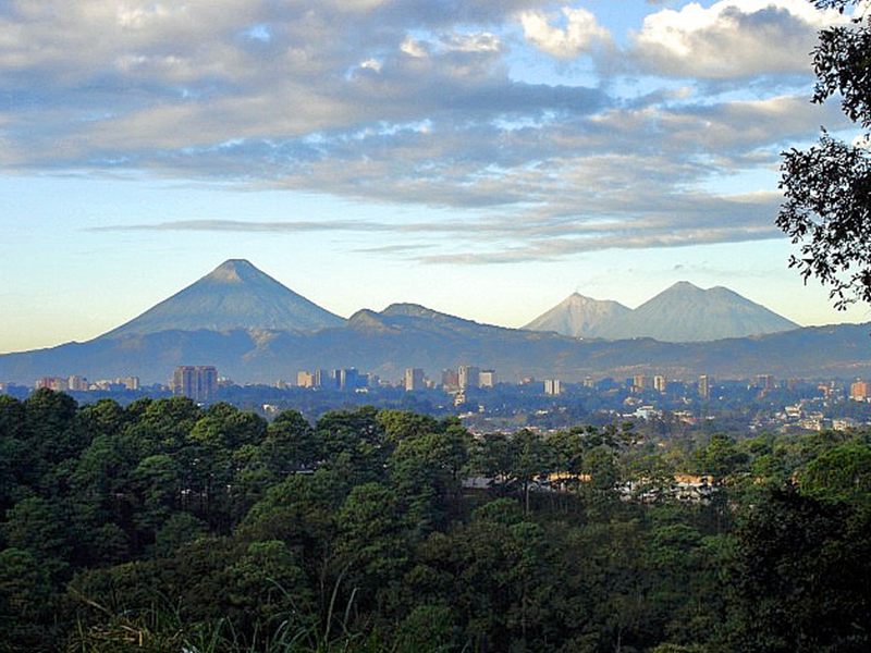
WHERE IS THE FUEGO VOLCANO IN GUATEMALA?

Fuego’s summit is 27 miles southwest of Guatemala City and the volcano is just 10 miles west of Antigua, Guatemala’s former capital.
In total, Guatemala has 37 active volcanoes. Fuego itself has already erupted once in 2018, with volcanic ash from the eruption spreading over a 12-mile radius.
It’s a type known by experts as a stratovolcano. Its steep-sides (or flanks) are what give it the shape that many of us have in mind when thinking about volcanoes.
Stratovolcanos are known for their periodic and explosive eruptions. The most well-known stratovolcano is probably Vesuvius, which erupted in 79 AD, burying the city of Pompeii under tons of volcanic ash.
WHY DO PEOPLE LIVE NEAR ACTIVE VOLCANOES?
More than half a billion people around the world live in the direct vicinity of volcanoes. Despite the known dangers, people still choose to live in such a high-risk location. But the question is, why?
Thanks to a phenomenon known as ‘upside risk’, the opportunities of living in such a place may offset the known risks. For farmers, one of the benefits of living near volcanoes is the fertile agricultural ground, enhanced by the volcanic ash. This also applies to areas that were covered by volcanic mudflows.
But there are also interesting social reasons for choosing to live in such a high risk area, with volcanoes shaping the cultural identity of the communities surrounding them
WHAT ARE THE RISKS TO SETTLING IN VOLCANIC REGIONS?

Dr Zoe Mildon, a leading expert in the field of Earth Sciences and a lecturer at the Univerity of Plymouth, explains the health dangers caused by deadly volcanic eruptions:
“There is the potential for lahars to develop, which are formed by volcanic ash mixing with water, which can engulf villages and cut off communities.
‘Volcanic gases […], if present in high enough concentrations can be poisonous. Inhaling volcanic ash can cause extensive damage to lungs, as volcanic ash particles are very tiny and very sharp.”
HOW IS THE VOLCANO IN GUATEMALA DIFFERENT TO THE ONE THAT RECENTLY ERUPTED IN HAWAII?
Kilauea vs. Fuego
No two volcanoes are identical. So it’s difficult to make direct comparisons between the two recent volcanic eruptions in Hawaii and Guatemala. But there are few distinct differences. For starters, Kilauea is a shield volcano, whereas el Fuego is a stratovolcano.
Dr Mildon briefly summarises the main difference between the Kilauea volcano in Hawaii and the Fuego volcano in Guatemala:
“A stratovolcano is a made up of layers of [multiple] volcanic products that form a stereotypical cone-shaped volcano. The volcano on Hawaii is a shield volcano, which typically has a shallower/flatter profile, and this is due to the difference in the type of lava produced by these two volcanoes.”
While the eruption in Hawaii drew attention for its dramatic lava flows, the one in Guatemala has unleashed pyroclastic flow. But, what exactly is pyroclastic flow? Dr Mildon further explains:
‘Pyroclastic flows are formed of hot air, ash, volcanic gases and rocks. They are incredibly hot – up to several hundreds of degrees C – and travel very fast, up to several hundred kilometres per hour, so they are incredibly hazardous to local populations.’
In contrast, the eruption on Hawaii is made up of lava flows of molten rock. These lava flows are moving at speeds of hundreds of metres per hour, which is far slower than pyroclastic flows. Therefore, while it is impossible to stop the flow of lava, it is possible to evacuate people away from hazardous regions that may be engulfed by lava.
The communities surrounding the two volcanoes are also very different. Kilauea is located within Hawai’s Volcanoes National Park, in stark contrast to the more densely populated villages surrounding Fuego in Guatemala.
Despite their technical differences, both volcanoes have been devastating. Whole communities and families affected will feel the traumatic effects of these disasters for years to come.
In the case of the Fuego eruption, concerns around the pyroclastic flows, volcanic mudflows and now also rainstorms have compounded the situation. The full extent of the need for shelter is not yet known.
We are sending a response team with volunteers from both the US and the UK.
DID WE KNOW IN ADVANCE THAT FUEGO WAS GOING TO ERUPT?

Dr Paul Cole, Associate Professor of Volcanology at the University of Plymouth, explains how the Fuego eruption essentially caught everyone by surprise:
‘This was an unexpected event. It was not forecast. This was the largest event at this volcano since 1974, when similar pyroclastic flows were generated. Nevertheless these pyroclastic flows seem to have gone further than previously. It is unclear why.’
In some instances, there are ‘warning signs’ that a volcano is about to erupt. Changes to the amount of volcanic gasses being emitted or changes to the actual shape of the volcano can indicate movement in the magma. But, unfortunately, there are no volcanic eruption forecasting systems which are 100% fail-proof.
How Do We Monitor Volcanic Activity?
Scientists around the world use a mixture of techniques to hear and see volcanic activity. This includes monitoring gas emissions, remote sensing such as satellite and thermal imaging, deformation (the changing shape of a volcano) and ground vibrations.
By observing each of these things scientist can build up data and look out for out-of-the-ordinary signals. Advances in technology have allowed us to better detect warning signals. This advancement gives local communities more time to make the difficult decision as to whether they need to leave behind their home, their belongings, and their community.
Running Away from Disaster
Speaking to German broadcaster DW, an anonymous Hawaii resident talked about their own personal experience, when they were forced to leave their home during the Kilauea volcano eruption.
‘It’s very stressful financially, and emotionally draining. It’s like you’re in a time loop where you’re on hold, waiting for it to be over so you can move on with life. This is where we grew up and raised our children. This is where we had family gatherings and parties with all our friends. Now it’s a place that no one wants to come, because is just too scary.’
Many thanks to the Earth Sciences department at the University of Plymouth for the expert advice and information.
When natural disasters and conflicts rob people of their homes, we can’t wave a magic wand to replace what was lost, but we can help. ShelterBox provides people with the tools to start the process of their own recovery. When people are plunged into crisis, normality is suspended. But good, quality shelter can cut through the chaos.